


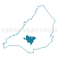
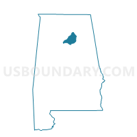
Locust Fork, Blount County, Alabama
About
Outline

Summary
| Unique Area Identifier | 521250 |
| Name | Locust Fork |
| County | Blount County |
| State | Alabama |
| Area (square miles) | 26.32 |
| Land Area (square miles) | 26.21 |
| Water Area (square miles) | 0.11 |
| % of Land Area | 99.58 |
| % of Water Area | 0.42 |
| Latitude of the Internal Point | 33.90590460 |
| Longtitude of the Internal Point | -86.62361600 |
Maps

Graphs
Select a template below for downloading or customizing gragh for Locust Fork, Blount County, Alabama


Neighbors
Neighoring Voting District (by Name) Neighboring Voting District on the Map
- Cleveland, Blount County, AL
- Dallas /Selfville, Blount County, AL
- Hayden, Blount County, AL
- Nectar, Blount County, AL
- Oneonta, Blount County, AL
- Remlap, Blount County, AL
- Rosa, Blount County, AL
- Sugar Creek, Blount County, AL
Top 10 Neighboring County Subdivision (by Population) Neighboring County Subdivision on the Map
- Oneonta CCD, Blount County, AL (14,908)
- Hayden CCD, Blount County, AL (12,844)
- Locust Fork CCD, Blount County, AL (8,731)
- Blountsville CCD, Blount County, AL (7,330)
- Cleveland CCD, Blount County, AL (3,789)
Top 10 Neighboring Place (by Population) Neighboring Place on the Map
Top 10 Neighboring Unified School District (by Population) Neighboring Unified School District on the Map
Top 10 Neighboring State Legislative District Lower Chamber (by Population) Neighboring State Legislative District Lower Chamber on the Map
Top 10 Neighboring State Legislative District Upper Chamber (by Population) Neighboring State Legislative District Upper Chamber on the Map
Top 10 Neighboring 111th Congressional District (by Population) Neighboring 111th Congressional District on the Map
Top 10 Neighboring Census Tract (by Population) Neighboring Census Tract on the Map
- Census Tract 506.02, Blount County, AL (8,923)
- Census Tract 507, Blount County, AL (8,731)
- Census Tract 505, Blount County, AL (7,329)
- Census Tract 501.02, Blount County, AL (7,050)
- Census Tract 502, Blount County, AL (3,789)
Top 10 Neighboring 5-Digit ZIP Code Tabulation Area (by Population) Neighboring 5-Digit ZIP Code Tabulation Area on the Map
- 35121, AL (15,570)
- 35079, AL (8,810)
- 35049, AL (3,996)
- 35133, AL (3,907)
- 35172, AL (2,986)
- 35097, AL (1,748)